
Most people who research Bandon before moving here spend their time on home prices, golf, and the coastline. Safety rarely makes the short list of concerns — and the numbers suggest that's not naive, just accurate. Bandon, a coastal city of 3,311 on Oregon's southern coast, posts a violent crime rate of 0.3 per 1,000 residents, which sits dramatically below both the Oregon state figure and the national average. For a town this size, that's not a statistical quirk — it reflects daily life here, where community safety conversations on local forums are more likely to be about storm surge and power outages than anything involving crime.
That doesn't mean the safety picture is uncomplicated. The Oregon coast carries a category of risk that inland cities simply don't have: Bandon sits within the Cascadia Subduction Zone, and parts of the city — particularly the low-lying waterfront — fall inside mapped tsunami inundation zones. This is not a reason to cross Bandon off your list. It is a reason to understand which neighborhoods sit above that line, and to take the city's posted evacuation routes seriously before you finish choosing where to live. The gap between being prepared and being caught off guard here is not about daily crime — it's about knowing your elevation.
What makes Bandon's safety profile genuinely unusual is the combination: among the lowest violent crime rates you'll find anywhere on the Oregon coast, a small, community-policing-oriented police department that operates around the clock, and a natural hazard profile that requires a different kind of thinking than most buyers are used to. Those two realities coexist. This guide works through both. For context on neighborhoods and how the city is laid out, the best neighborhoods page covers the geographic picture in detail.
Whether you're trying to decide between Bandon and a larger coastal city, or you've already zeroed in on the Oregon coast and want to understand what safety actually looks like day-to-day, the sections below break down the crime data, the police department's capacity, the natural hazard zones by neighborhood, and what longtime residents say keeps them here.

How Bandon's Crime Rate Compares
| Measure | Bandon | Oregon | National | vs. national |
|---|---|---|---|---|
| Violent crime (per 1,000) | 0.3 | 3.3 | 3.7 | 92% lower |
| Property crime (per 1,000) | 17.1 | 24.5 | 18.4 | About the same |
State and national figures — Bureau of Justice Statistics, Crime Known to Law Enforcement, 2024 (tables 2 and 3). City figures — AreaVibes/Nextdoor, FBI Uniform Crime Report data (2024). City rates come from a different reporting series than the state and national benchmarks, so read the comparison as a direction, not a precise multiple.
Bandon records a violent crime rate of 0.3 per 1,000 residents — a figure that isn't just low for a coastal Oregon town, it's low by almost any standard. The Oregon state violent crime rate runs at 3.3 per 1,000, and the national violent crime rate sits at 3.7 per 1,000. Bandon's rate is a fraction of both.
Property crime tells a similar story. Bandon has a property crime rate of 17.1 per 1,000 residents. The Oregon state property crime rate is 24.5 per 1,000, and the national property crime rate is 18.4 per 1,000. In other words, Bandon comes in below Oregon and close to — actually under — the national figure on property crime too. That's meaningful in a state where coastal towns sometimes see elevated property crime tied to seasonal tourism.
The most recent reporting year logged zero murders in Bandon. That's consistent with what residents say when the topic comes up locally: online community conversations here are almost entirely about weather events, power disruptions, and coastal conditions — not personal safety from crime. That resident experience and the statistical picture reinforce each other.
For a city of 3,311 people, it's worth keeping one thing in mind about crime rates: small absolute numbers move percentages sharply. A handful of incidents in a year can shift a rate noticeably. The trend direction, however, has been consistently downward across multiple recent years — and the low base is real, not a statistical artifact.
Bandon Police Department and Local Enforcement
Bandon runs a lean but full-time police department: a chief, a patrol sergeant, four patrol officers, an administrative assistant, and an active reserve officer program. The department operates 24 hours a day, seven days a week — which matters in a small coastal city where the nearest county sheriff's substation isn't walking distance.
The Bandon Police Department uses a community-policing model, with proactive foot and vehicle patrols, neighborhood watch coordination, and youth outreach as explicit program elements. In a city this size, that approach translates into officers who know the streets and the regulars. It also means response times are generally competitive with what you'd find in a comparably sized inland Oregon city.
The department is supplemented by the Coos County Sheriff's Office, which also provides patrol coverage in the surrounding area. That layered coverage matters for a city at the edge of Coos County, where some incidents and calls cross jurisdictional lines naturally.
One practical consideration: a full-service acute care hospital is located inside city limits and provides 24-hour ambulance service. For a town this size — the 96th-largest incorporated city in Oregon — having a licensed acute care hospital within city limits is not something to take for granted. It closes a gap that many comparably sized coastal Oregon communities don't have.

Neighborhood-Level Safety: What the Geography Tells You
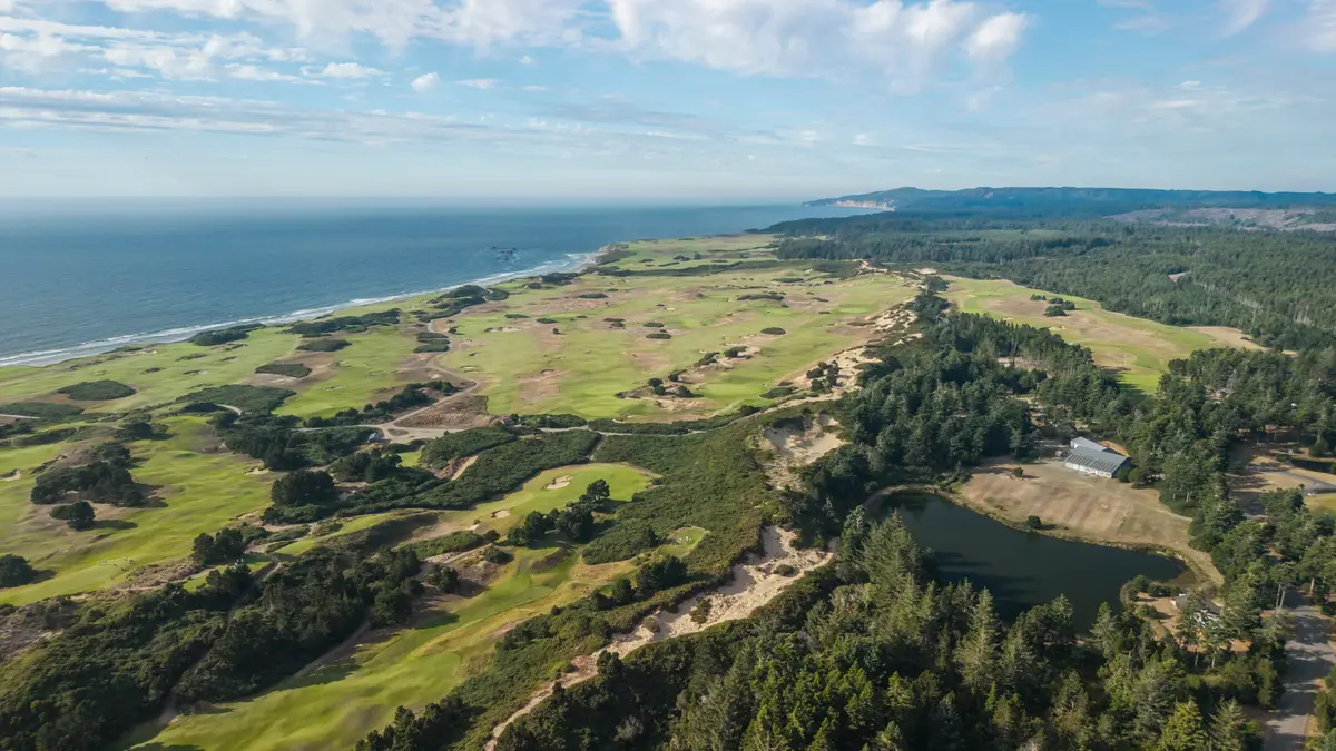
Crime in Bandon doesn't cluster by neighborhood the way it does in larger cities. With a population of 3,311 and a violent crime rate this low, the neighborhood-level safety picture is less about avoiding a bad block and more about understanding what each area's character means in terms of day-to-day exposure — including natural hazard exposure, which varies significantly by elevation.
Old Town and South Jetty
Old Town Bandon is the waterfront commercial district — a boardwalk, shops, restaurants, and the working marina along the Coquille River. It's an active pedestrian area that draws both residents and tourists, particularly during the warmer months. South Jetty sits immediately adjacent to it at the river's mouth. These are low-lying areas, and both fall within the mapped tsunami inundation zone. Crime-wise, the activity level here is higher than in quieter residential pockets, and that's worth factoring in when comparing neighborhoods — but it's not a high-crime area by any objective measure. For deeper context on these neighborhoods, see the best neighborhoods guide.
Bandon Heights and Bluff-Top Areas
Bandon Heights and the neighborhoods near Coquille Point sit above the tsunami inundation zone. From a natural hazard standpoint, this is a meaningful distinction — one that the state's own inundation modeling makes explicit. The bluff neighborhoods have a quieter residential character, with less foot traffic from seasonal visitors. They're not immune to property crime (no neighborhood in any city is), but they combine lower natural-hazard exposure with a calmer day-to-day profile.
Ocean Trails, Sea Pines, and the Southern Reaches
The neighborhoods that extend south and inland — Ocean Trails, Sea Pines, Sea Turtle Terrace, Bandon Coast Village, and Seabird Village — sit in a mix of elevation profiles. Some are on higher ground; others have pockets that could fall within inundation modeling depending on scenario severity. Checking your specific address against Oregon DOGAMI's inundation maps before settling on a neighborhood is the single most actionable safety step a buyer can take in this city.
Bandon Dunes Golf Resort operates just north of the city limits. That operation draws heavy seasonal visitor traffic, which adds a transient population dimension to the northern approaches to the city — a factor worth noting when comparing the character of neighborhoods near the resort corridor versus those deeper in the residential core.
Looking to buy in Bandon? Estimate your payment.
Enter your numbers to see an estimated monthly mortgage payment.
Estimate only. Excludes HOA fees and mortgage insurance. The interest rate above is a starting point, not a quoted rate — replace it with your own to see real numbers. Insurance is a flat placeholder, not a Bandon quote.
The Cascadia Subduction Zone: What Bandon Residents Actually Plan For
Tsunami risk is the part of Bandon's safety picture that crime statistics don't capture — and it's the part that locals think about more concretely than most newcomers expect. Oregon DOGAMI has produced detailed inundation maps for Bandon covering scenarios from a Mw 9.1 Cascadia Subduction Zone earthquake. The maps are publicly available. The city has posted marked evacuation routes and published a tsunami evacuation brochure. These are not precautionary gestures — they reflect a genuine planning reality.
Scientists currently estimate roughly a 37% probability that a megathrust earthquake of magnitude 7.1 or greater will occur along the Cascadia Subduction Zone in the next 50 years. That probability applies to the entire Pacific Northwest coast, not just Bandon. What makes Bandon-specific planning important is the local geography: wave arrival times after a Cascadia event are relatively short, and DOGAMI's worst-case analysis found that some Bandon residents in low-lying areas would need to jog or run — not just walk — to reach high ground. Liquefaction could also complicate evacuation in certain areas.
This is a planning concern, not a reason to live in daily fear. Tens of thousands of people live on the Oregon coast and treat tsunami preparedness the way inland homeowners treat earthquake kits: something you take seriously, build a plan around, and then go on with your life. The key difference in Bandon versus an inland valley is that knowing your elevation and your evacuation route matters concretely here.
The practical takeaway for anyone choosing a neighborhood: the bluff-top areas above the inundation line offer a different risk profile than the waterfront and low-lying parts of the city. That distinction is worth factoring in early — not as a reason to avoid the waterfront entirely, but as a variable that should be on your checklist when comparing specific locations.
Other Coastal Hazards
Winter storms along the southern Oregon coast regularly produce power outages, wind damage, and hazardous surf. These are recurring seasonal realities rather than rare events. Residents here factor in generator access, storm-ready infrastructure, and the occasional road disruption in ways that people relocating from inland Oregon or California often don't anticipate until their first December. It's the kind of thing that becomes ordinary quickly — but the first winter can surprise people who moved expecting the coast to be milder than it is.
What a Safe Move to Bandon Actually Looks Like
The honest summary: on the crime side of the ledger, Bandon is among the safer small cities on the Oregon coast by any data series. A violent crime rate of 0.3 per 1,000 residents speaks for itself against both Oregon's rate and the national rate. Property crime is comparably low. The police department is small but operates continuously and uses a community-oriented approach. That's the day-to-day reality for residents here.
Where Bandon asks more of its residents than most Oregon cities is in natural hazard preparedness. A responsible approach before deciding on a neighborhood here looks like this: pull the Oregon DOGAMI inundation maps for your specific address. Check your parcel's elevation. Know which evacuation route applies to where you'd be living. If you're drawn to the Old Town waterfront or the South Jetty area, understand that you're in a mapped inundation zone and plan accordingly — which many residents do, and do confidently.
The bluff neighborhoods above the inundation line — Bandon Heights in particular — give you the added margin of elevation if that's a priority. The trade-off is that you're further from the waterfront energy and walkable access to Old Town. There's no wrong answer, but it should be a conscious choice rather than something discovered after the fact.
People who move OUT of Bandon tend to cite the isolation — it's about 25 minutes to Coos Bay, and a serious shopping run or specialist medical appointment means a longer drive. That's not a safety issue in the traditional sense, but it's worth naming honestly: in an emergency, Bandon's distance from a larger city is a real variable. The presence of a full-service acute care hospital inside city limits closes some of that gap — but not all of it.
What keeps most residents here isn't a trade-off calculation. It's that the combination of genuinely low crime, a tight-knit community where a police department knows the town it serves, and a coastal setting that most people find worth the natural hazard preparation adds up to something hard to replicate at this price point. The safety picture, understood fully, is a strong one — provided you do the homework on elevation before you decide on a neighborhood.
Local Expert Takeaway: Bandon's crime numbers are genuinely low — not just 'small town' low, but statistically low against both Oregon and national benchmarks. The question safety-minded buyers should spend more time on isn't crime; it's elevation. Knowing whether a specific address sits above the tsunami inundation line is the most consequential safety research you can do before choosing a neighborhood here. Pull the Oregon DOGAMI maps, check your route to high ground, and factor that into your neighborhood comparison alongside the things that make Bandon worth the move in the first place.
Quick Takeaways & FAQs
✅ Bandon has a violent crime rate of 0.3 per 1,000 residents — dramatically below the Oregon state rate of 3.3 per 1,000 and the national rate of 3.7 per 1,000, making it among the safest small cities on the Oregon coast.
⚠️ Low-lying areas including the Old Town waterfront and South Jetty sit within Oregon's mapped Cascadia Subduction Zone tsunami inundation zone — a planning reality every prospective buyer should research before settling on a neighborhood.
📍 Bandon Heights and the bluff-top neighborhoods near Coquille Point sit above the tsunami inundation line, offering a meaningfully different natural hazard profile than the waterfront areas below.
What is Bandon, Oregon's crime rate compared to the state average?
Is Bandon's waterfront and Old Town area safe?
What is the tsunami risk in Bandon, and should it affect where I live?
Does Bandon have a full-time police department?
Which Bandon neighborhoods are safest from natural hazards?
Moving to Oregon?
Tell us what you need help with and we'll connect you with local resources.
