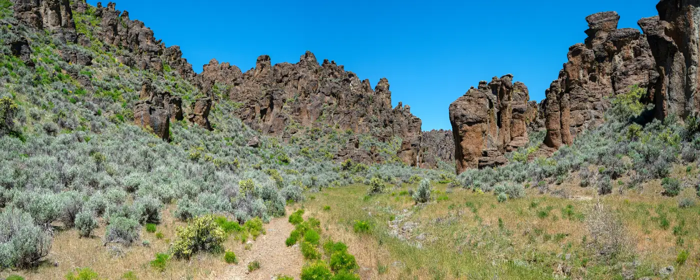
Most people driving south on Highway 46 into Gooding see flat farmland and the occasional dairy operation and assume the recreation options are equally sparse. They're wrong. Twelve miles up that same highway, the Bennett Hills erupt into a landscape of volcanic rhyolite spires, natural arches, and mushroom-cap hoodoos that most Idahoans outside Magic Valley have never visited. The Gooding City of Rocks Wilderness Study Areas — more than 21,000 BLM acres in total — are the area's signature outdoor asset, and they sit practically in the city's backyard.
Inside town, the Gooding Recreation District runs the outdoor swimming pool at East Park on Illinois Street, and a new bike park along Clover Creek on 4th Avenue West has been taking shape since early 2024 — the result of nearly a decade of community lobbying and a state Recreational Trails Program grant application totaling $189,891. For a city of under 4,000 people, the infrastructure being built here punches above its weight. The Gooding Basque Association's annual July picnic at the Basque Center on Euskadi Lane adds a cultural layer to the recreation calendar that you genuinely won't find anywhere else in the Magic Valley.
The bigger outdoor picture extends southwest to Hagerman in about 25 miles, where Hagerman Fossil Beds National Monument, Thousand Springs State Park, Blue Heart Springs, and Snake River kayak launches open up a completely different season of recreation. Gooding sits at the geographic center of all of it — close enough to make weekend plans without a long drive, far enough from the tourist crowds that most of these places feel uncrowded even in summer.
Whether you're considering a move or just researching what daily and weekend life looks like here, the sections below break down Gooding's signature parks, trail options, water recreation, and how the outdoor calendar shifts across the four seasons.

Gooding City of Rocks: The Backyard Wilderness Most Newcomers Miss
The BLM-managed Gooding City of Rocks complex is the single most underrated piece of public land in the Magic Valley — and it's 12 miles from downtown Gooding on the same highway that runs through town. The East Wilderness Study Area covers 14,743 acres; a second WSA adds another 6,287 acres; and the adjacent Little City of Rocks WSA tacks on 5,875 more. Together, they form a contiguous volcanic landscape at elevations ranging from 4,080 to 5,616 feet, shaped by ancient pyroclastic eruptions that left behind welded tuff formations the Bennett Hills are now famous for.
Walking through the hoodoos feels genuinely disorienting — spires, arches, and formations that look engineered but are entirely geological. Ancient petroglyphs and surface lithic scatters appear throughout the area, evidence of human presence going back thousands of years. Elk, mule deer, coyote, birds of prey, and upland game are all regularly spotted, which makes early-morning hikes especially productive for wildlife watching.
The Gate Rule Nobody Tells You
The access road into the Gooding City of Rocks is privately owned — and the gate closes when the road is wet. That's not a minor caveat. An unexpected spring storm or a muddy June weekend will turn your plans around before you reach the trailhead. Check conditions before you drive out, and plan visits for dry-weather windows from late spring through early fall.
Dispersed camping throughout the WSAs is free and requires no permit. Day hiking, mountain biking, and horseback riding are all permitted. There are no developed facilities — no water, no toilets, no marked campsites — so come self-contained. The BLM sign at the Highway 46 turnoff 12.5 miles north of Gooding marks the Little City of Rocks trailhead access; the graded dirt road to the trailhead is manageable for most vehicles when dry.
One thing that regularly surprises people six months after moving to Gooding: this landscape stops feeling exotic and starts feeling like theirs. Weekend regulars build routines around it — early hikes before the heat sets in, mountain bike laps in September when the air cools, dispersed camping in October when the crowds (such as they are) disappear entirely.
Trails Near Gooding: What to Hike and What to Know First
The Gooding trail network is compact but genuinely varied — you can do an easy half-day lava tube walk or a moderate 5-mile loop with real elevation gain, all within the same general area north of town on Highway 46.
| Trail | Distance | Elevation Gain | Difficulty | Highlight | Vehicle Needed |
|---|---|---|---|---|---|
| Little City of Rocks Loop | 5.0 mi | 839 ft | Moderate | Hoodoos, arches, petroglyphs | Standard (when dry) |
| Dead Horse to Tea Kettle Cave | Shorter, easy | Minimal | Easy | Basaltic lava tube, natural skylight, ferns | 4WD / high-clearance beyond parking |
| Gooding City of Rocks (dispersed) | Open / variable | Variable | Easy–Moderate | Rhyolite spires, wildlife, free camping | Standard (when dry) |
| Hagerman Fossil Beds Oregon Trail | 3.0 mi | Low | Easy | Wagon ruts, Snake River Overlook, birds | Standard |
Tea Kettle Cave deserves its own sentence: it's a basaltic lava tube with a hole in the ceiling that lets in a column of light, with ferns growing where the moisture collects. The road beyond the parking area requires 4WD or high clearance — don't test your sedan's luck past the lot.
The Oregon Trail Connection at Hagerman
The 3-mile Oregon Trail hiking route at Hagerman Fossil Beds National Monument — about 25 miles southwest — is a completely different experience from the Bennett Hills terrain. You're walking among still-visible pioneer wagon ruts above the Snake River, with bald eagles, ducks, and geese common along the canyon. The monument straddles Gooding and Twin Falls counties and is co-managed with Idaho Department of Parks and Recreation under a partnership established in 2021. It makes an easy half-day out from Gooding when the City of Rocks access road is wet and you need an alternative.
One honest note: Gooding doesn't have a maintained urban trail network connecting neighborhoods to open space. The outdoor recreation here is destination-based — you drive to the trailhead. If walkable greenway access within the city is a priority, that's the real trade-off to understand before you move here.
City Parks, the Pool, and the Bike Park Taking Shape on 4th Avenue
East Park, on Illinois Street between 3rd and 4th East, is Gooding's main in-town recreation anchor. The outdoor Gooding Public Swimming Pool sits here, operated by the Gooding Recreation District and offering swimming lessons for all ages. As an outdoor facility, it operates seasonally — the city's own website confirms it's active, but verify current-season hours before you plan around it. East Park is where summer afternoons in Gooding tend to concentrate: families with younger kids, swim lesson drop-offs, the general social gravity of a small city's only public pool.
The Bike Park: Nine Years in the Making
The story of the 4th Avenue Bike Park at Clover Creek is a useful window into how Gooding actually gets things done. Local riders first floated the idea in 2015. By 2018, the biking community was actively lobbying. Construction finally started in January 2024, adjacent to the existing skate park at Clover Creek on 4th Avenue West. The city applied for an Idaho Department of Parks and Recreation Recreational Trails Program grant to cover the bulk of the $189,891 total project cost — requesting 80% federal funding with a 20% local match. The grant application made Idaho IDPR's FY2025 list, confirming the project was moving through state funding channels.
When complete, the bike park will give younger riders and BMX enthusiasts a dedicated built facility rather than improvised spots — a meaningful addition for a city this size. The skate park next door has been the informal gathering point for that crowd for years; the bike park formalizes what was already happening at the Clover Creek corridor along 4th Avenue West.
The Basque Picnic: A July Anchor You Won't Find Elsewhere
The Gooding Basque Association's annual picnic happens the third Sunday of July at the Basque Center at 285 Euskadi Lane. This isn't a generic community fair — it's weight-carrying and lifting contests for men, women, and children, traditional cultural dancing, and a gathering rooted in the Basque sheepherding history that shaped this part of Magic Valley. For newcomers, it's one of the first events that makes Gooding feel genuinely specific rather than interchangeable with any other small Idaho city. Put it on the calendar before your first summer here.
Looking to buy in Gooding? Estimate your payment.
Enter your numbers to see an estimated monthly mortgage payment.
Estimate only. Excludes HOA fees and mortgage insurance. The interest rate above is a starting point, not a quoted rate — replace it with your own to see real numbers. Insurance is a flat placeholder, not a Gooding quote.
Water Recreation and the Snake River Corridor: What's Within Range
Gooding itself doesn't sit on a river. That's an honest fact about the city — and it shapes how residents access water recreation. The answer is Hagerman, roughly 25 miles southwest, where the Snake River corridor opens up into one of the most productive outdoor recreation zones in southern Idaho.
| Destination | Distance from Gooding | Activities | Notes |
|---|---|---|---|
| Hagerman / Snake River | ~25 mi SW | Kayaking, boating, fishing, swimming | Rentals available in Hagerman |
| Blue Heart Springs | ~25 mi SW | Swimming, kayaking | Spring-fed, turquoise water |
| Billingsley Creek | ~25 mi SW | Fishing, wildlife watching | Trout habitat |
| Ritter Island | ~25 mi SW | Walking, birding | Part of Thousand Springs State Park |
| Thousand Springs State Park | ~25 mi SW | Scenic viewing, hiking, fishing | Multiple units along Snake River |
| Hagerman Fossil Beds NM | ~25 mi SW | Hiking, birdwatching, history | Oregon Trail wagon ruts visible |
Blue Heart Springs is the marquee destination — a spring-fed pool that runs a striking turquoise color against the basalt canyon walls, accessible by kayak or paddleboard. Rental companies in Hagerman offer kayaks and paddleboards, which means you don't need to own gear to access it. Billingsley Creek nearby draws anglers after trout, and Ritter Island within Thousand Springs State Park gives birders a quieter alternative to the more-trafficked Snake River access points.
What This Means Season to Season
Spring and early summer are the prime Snake River window — water levels are manageable, the canyon walls are green, and bald eagles are still working the river before the summer crowds thin them out. Late summer shifts attention back toward the Bennett Hills, where the City of Rocks terrain is at its best in September and October. Winter closes the access road to the WSAs during wet stretches, which effectively redirects recreation toward Twin Falls or indoor options for a few months.
The honest read: Gooding residents who get the most out of outdoor life here treat the city as a base camp rather than a destination in itself. The City of Rocks is north. The Snake River is southwest. Both are close enough to be genuinely part of your weekly or weekend rotation — not just an annual day trip. That's the recreation case for living here, stated plainly.
Local Expert Takeaway: The City of Rocks access road closes when it's wet — and it will be wet more often than you expect in April and May. Locals time their first visit of the year for late May or June, after the Bennett Hills dry out. Once you've learned that rhythm, the WSA complex north on Highway 46 becomes a genuine weekly habit: mountain bikes in September, early hikes in June before the heat builds, dispersed camping in October when you'll likely have the whole area to yourself. The Clover Creek corridor on 4th Avenue West is where the younger crowd gathers around the skate park, with the new bike park adding another draw. For summer afternoons with kids, East Park on Illinois Street is the social center of gravity. And if you arrive in Gooding in late July, the Basque picnic at 285 Euskadi Lane is the single best first-look at what makes this community different from every other small city in Magic Valley.
Quick Takeaways & FAQs
✅ More than 21,000 acres of free BLM wilderness — the Gooding City of Rocks complex — sits just 12 miles north of downtown on Highway 46, with no permit required for hiking, mountain biking, or dispersed camping.
⚠️ Gooding has no maintained urban trail network connecting neighborhoods, and the access road to the City of Rocks closes when wet — outdoor recreation here is destination-based and weather-dependent.
📍 The Gooding Basque Association's annual weight-lifting and cultural dancing picnic, held the third Sunday of July at 285 Euskadi Lane, is one of the most genuinely local events in the Magic Valley.
Is the Gooding City of Rocks the same as the City of Rocks National Reserve near Almo?
Can I camp at the Gooding City of Rocks, and does it cost anything?
What is the most challenging hike near Gooding?
Does Gooding have a public swimming pool?
How far is Gooding from the Snake River and water recreation like kayaking?
Moving to Idaho?
Tell us what you need help with and we'll connect you with local resources.
